From 30. May to 5. June 2016 there were international paramotor competitions held in Saaremaa, Estonia.
1-st FAI World Paramotor Endurance Cup 2016 and 3-rd Nordic Open Paramotor Endurance Race 2016 were held at the same time with 4 countries involved and with the most far participants arrived from Saudi Arabia.
For the safety on pilots, navigating in the area of 3000 km 6 continous days and for 5 hours a day, there were special GPS P-trackers supplied by Metrotec Estonia. Those incredible trackers show every pilot's position online in real time and offer a great possibility to follow the whole event even from the other part of he world, but the most important feature is radical impovement of safety in such competitions. Now every pilot is visibile to the organisers as well, full time and in case of any emergency or outlanding, pilot's position is easy to identify for rescue or recovery. Trackers provided by Metrotec even have a special SOS button for precise location of the pilot in need.
There were already many cases were GPS trackers were needed quite seriously. For example, Estonian pilot Ott Maaten landed Thursday on the very small island south of Saaremaa and it appeared to be so soft soil that he nearly drowned. Luckily his position was located very fast, the rescue operation was activated immediately and situation solved. Afterwards he continued the race with full energy.
It has become a tradition for Metrotec to track the movements of various groups of adventure travellers or sports folk, be it for the 63 km cross-country ski run known as the Tartu Marathon, an 80 km swim across the Gulf of Finland, an off-road vehicle expedition to Mongolia or the Amphibear's trip around the world.
This time, the focus is on a 4x4 travel venture to Central Asia. The travellers will pass the giant gas crater known as the Door to Hell in the Karakum Desert, the underground lake Kow-Ata, various sections of the famous Silk Road, the Pamir ?motorway? that runs along the border of Afghanistan, take in a great deal of wonderful natural sights and cultural experience, and discover many near-forgotten villages and markets. The Pamir highway is second highest in the world in terms of elevation, rising up to 4655 m above sea level. The company will test their equipment in conditions in which they only have themselves and their good luck to rely on.
Click the link metrotec.ee/4x4 to follow the location and progress of the company.
News and photos of the trip are available through Facebook facebook.com/4x4reisid.
Amphibious vehicles have been built for different purposes all the time. But how many engineers have constructed a cross-country vehicle that can cross oceans as well? There is one for certain - Mait Nilson. Click on www.amphibear.com and read, how that happened. A grande finale crowns years of dreaming and work - on 2nd November 2013 Mait begins his round the world voyage. The first serious water obstacle will be the Strait of Gibraltar. Click on www.metrotec.ee/amphibear and monitor Amphibear on its 9 month yourney.
mobile.metrotec.ee is a mobile version of web based service displaying the locations of your vehicle fleet on a smartphone or an Ipad. Open web browser in your smart device, select address mobile.metrotec.ee and you will see the locations of vehicles in your fleet, may exchange info with the drivers, mark (new) destinations to the map and send them to navigation devices in drivers cabin.
Again it is time for Tartu Marathon. And again Tartu Emergency Medical Services provide the participants with medical safety net - on skis and on wheels. And naturally, for better and faster allocation of valuable resource, their locations and activities are visible to dispatchers. All in the interest of a potential patient who has no address. And even more valuable due to harsh weather.
Both hardware and software solutions are still 100% Estonian, more reliable than ever before. And again, for demonstration purposes, has Metrotec Llc equipped a group of marathon participants with tracking devices and created a webinterface to monitor their progress.
Click on www.metrotec.ee/tartumaraton2011 to trace the skiing enthusiasts of different level as well as the movements of Medical Services.
A new product F-Track FM "brings driver into office". Remotely controlled navigation terminal in cab creates a two-way communication with map support between drivers and office.
A destination is marked on the map in office. A mouse click transmits it into drivers navigation terminal. Maximum comprehension is achieved through minimal transfer of data!
The driver accepts a task and navigation terminal guides him to destination. In addition to vehicles location and job status the office can see destination and estimated time of arrival.
The journey to destination is observable from the office in real-time. Detailed navigation instructions save both time and fuel. A work order visualized on the map together with directional instructions of the navigator makes driver's job easier and reduces stress.
In addition to automated communication, the navigation terminal enables standard text messaging between drivers and office. Simple and fast communication improves efficiency in responding to unscheduled events - from unforeseen order to broken tire.
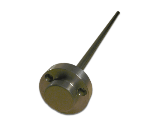
F-Track is an efficient and convenient remote control system that tracks the movements and fuel consumption of vechicle fleets. It is useful to any company that is interested in observing their vechicles in real time and in retrospect - including but not limited to (international) cargo transport, passanger traffic or construction equipment.
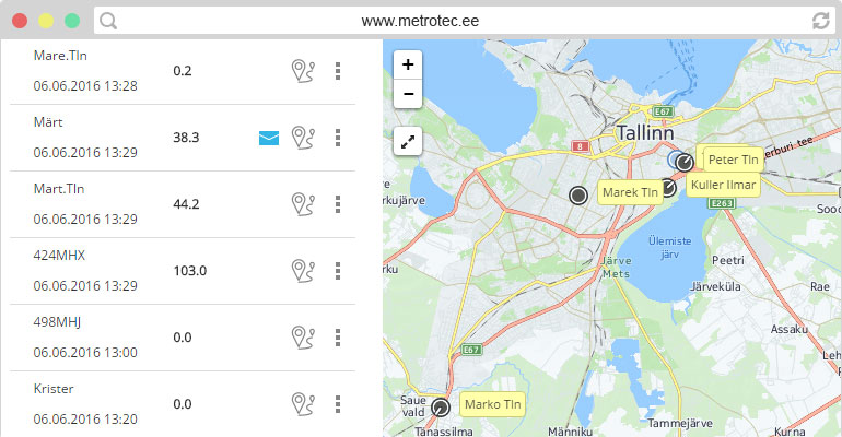
Clear overview of the fleet - moving and standing, working and idle vehicles. Were the chosen route and speed optimal? How long it took to load a cargo? A route displayed on map provides exact answer. Even better - use playback and follow the route.
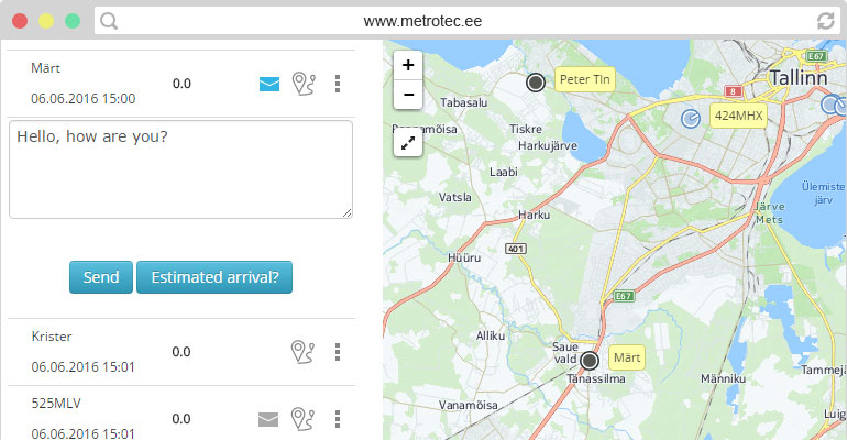
Garmin's navigator, assigning tasks and destinations, estimated time of arrival .. Remotely controlled navigation terminal near drivers seat creates two-way data exchange between office and driver, including map support. A destination marker (POI) on a map in office is transferred with a mouseclick to the drivers navigation terminal. Maximal understanding through minimal effort! The driver accepts the task, navigation device guides the driver. The office sees, in addition to vehicles location and busyness, destination data and Estimated Time of Arrival. The yourney can be observed in real time. Precisely determined destinations save time and fuel. A task specified on map combined with navigation terminals directions makes drivers work simple and stress-free. In addition to automated messages, the navigation terminal enables two-way communication between office and driver. Simple and fast communication increases flexibility in reacting to events - from an unexpected job to a broken tire.
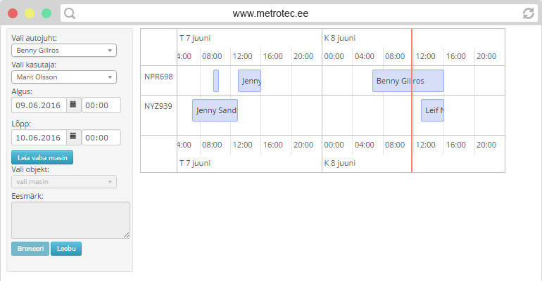
Collective use of vehicles is one of the options for optimizing fleet size. The reservation system enables the user to reserve a vehicle for the upcoming period and offers a great overview of the utilization of the collective resource in general. Depending on the device installation, the central lock and signalization may be controlled from the user’s mobile phone.
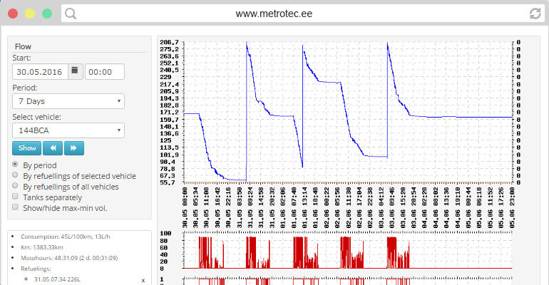
Data is presented in comparative tables to increase clarity. Sort vehicles by fuel consumption, mileage or any other meter. A data presented as chart or graph obtains a new level of clearance. A moment explains what happens in vehicles fuel tank. Dynamic scale will present clearly a minuscule fuel loss.
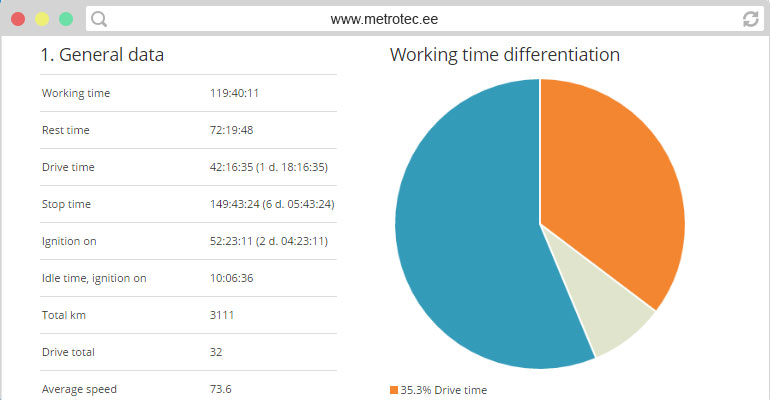
F-Track system produces continuous high quality data stream by registring periodically readings from connected sensors, detecting changes in the readings and storing 24/7 movement history. Processing, filtering and concentrating this data provides users with different reports. The reports reflect driving, waiting and idle periods, work and rest time and movement speed as well as mileage, refueling, average fuel consumption per mileage and working hour. Interactive user interface enables odometer based task diary. User may export reports as needed in html, pdf, csv or xls formats.
Acceleration, deceleration, use of cruise control, tachometer readings - they are all variables in the equatation of average fuel consumption. Everybody is trying to make sure, that fleet is exploited correctly and sustainably. Readings from on-board computer allow to appraise driving habits and proper maintenance.
F-Track system produces precise and reliable data. It is suitable for analysing business processes as well as payroll calculations. The data of F-Track system is compatible with value management software and accounting programs. F-Track API is a convenient tool for integrating with another info system. Formulate a query and "mine" quality data directly from our database be it working hours, mileage or something else. A little low level programming work and entire import is automatic and "tailor made".
It is important to be operatively informed about problems. Most popular alarm is currently SMS message indicating fuel loss. Operative reaction has often disturbed fuel thieves, occasionally allowing to capture them. Also, it is important to stay on the right side of law - be it insurance, routine maintenance or mandatory resting hours. Alerting system allows to divide events into different categories and to inform directly respective responsible persons. The number of receivers is unlimited and different receivers can be assigned to individual vehicles, so that every E-mail and SMS reaches correct person - be it security alert, fuel loss, servise message or important message from driver.
By creating and administering user accounts you can provide workers, business parners, clients, etc. with different levels of access to the data of F-Track system. Somebody wants a certain report about certain vehicle. Somebody wants to track a cargo. Somebody wants to see exact hours they were billed for. Flexible system of sub-accounts with different profiles and privileges combined with tying different users to different vehicles allows for taylor made customisation of access to data.
Metrotec LLC